


SANDY TWP A Voting District, Stark County, Ohio
About
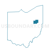
Outline

Summary
| Unique Area Identifier | 652018 |
| Name | SANDY TWP A Voting District |
| County | Stark County |
| State | Ohio |
| Area (square miles) | 0.64 |
| Land Area (square miles) | 0.64 |
| Water Area (square miles) | 0.00 |
| % of Land Area | 100.00 |
| % of Water Area | 0.00 |
| Latitude of the Internal Point | 40.65496600 |
| Longtitude of the Internal Point | -81.29028160 |
Maps


Graphs
Select a template below for downloading or customizing gragh for SANDY TWP A Voting District, Stark County, Ohio


Neighbors
Neighoring Voting District (by Name) Neighboring Voting District on the Map
- PRECINCT ROSE TWP, Carroll County, OH
- SANDY TWP 1 Voting District, Stark County, OH
- SANDY TWP 2 Voting District, Stark County, OH